I conceived a notion to go hiking on the Appalachian Trail
this summer. The AT is a continuously
linked series of marked trails that stretches from Maine to northern Georgia
running along the Appalachian Mountains that form the eastern spine of the
North American continent. Opened in the
1940s the AT covers a distance of about 2200 miles through wild mountain
country. There are about 250 simple
shelters along the route usually with a privy and nearby spring. There are ample descriptions both in print
and online of the routes and the terrain to be expected. It all seems rustically romantic.
The reality of actually hiking the
trail is somewhat different. Let me give
you some idea of what it is really like to hike the AT. First, you need to wear some comfortable
clothes; some you really like because you will not be changing them very
often. Then take a backpack; one with
some weight to it. Put in a concrete
block for starters. Shoulder this burden
and then take a walk. Imagine a big city
where almost all the people are gone for some reason. Now think of a parking garage, a big one, one
that is still got construction going on so that there are all sorts of boards,
blocks and debris strewn around the ramps.
Now, with your pack on your back walk up ten or twelve levels of ramps,
stepping over and around the stuff on the ramps. When you reach the top look around for a
moment, then go to the other side and walk down. Do that to three or four similar structures,
each a block down from the rest. Then climb
up the stairs of a sky scraper - a big one.
It is not unusual to see elevation changes of +1,000 feet on segments of
the AT, which is more than the height of the Empire State building. So after you do those half dozen big parking
garages, walk to the top of that sky scraper carrying your pack. Look around and then climb back down to do a
few more of those 10 story garages.
Remember, you cannot hold on to the banister, either, adding to the
chance that you will take a serious tumble if you are not careful. Oh, and you cannot use your cell phone,
either; no coverage.
At the end of your day, it is time
to camp. Think of joining a bunch of
nice homeless people on the street. Of
course, the only toilet you can use is one of those porta-potties you see
around construction sites. Dinner is
warmed up dehydrated food, prepared by adding heated water to a pouch. You can get water, but only cold water. You sleep on a pad about ½ inches
‘thick’. The next morning you eat your
packaged breakfast and do it again.
Every three to five days you might be able to spend the night in a
hostel. Think of a bunk in your local
homeless shelter. But at least there is
plumbing available and a hot meal there.
That is a mere simulation of back country hiking.
Of course actually walking the
trail is much harder than this. The
paths are full of large rocks and roots so you have to be careful of where you
place your feet. You walk rain or shine. That means the trails, which often are cut
into +65 degree slopes are wet and treacherous.
A slip could lead to a very nasty fall.
Likewise the boulders that you must clamber over also become slick in
the rain. A sprained ankle is no joke
when you are five miles from any road and there is no cell phone coverage. As far as I am concerned the whole
Appalachian Trail is giant outdoor sanatorium for non-violent lunatics.
Every year an estimated between 2-3
million people hike at least some portion of the AT. And about 3,000 fools, called thru-hikers, set
out to trip to hike the entire length of the AT in one season. About a quarter of them actually complete the
feat, typically taking five to seven months.
So, if the Appalachian Trail is so
difficult why do so many people chose to hike it? There are a lot of reasons. First, doing any long hike in the outdoors is
a challenge, one that you can tailor to your own level, from a short, simple
day hike to hiking the entire length of the trail. Many people simply enjoy being out of doors,
especially wilderness areas. They
appreciate the wild beauty and incredible variety of the AT. We went from freezing fog and rocky alpine
evergreen terrain to rolling deciduous forest, to open moorlands, to open green
pastures, to lush rhododendron plants which overhung the path all in one day. It was almost like walking from one planet to
another. “Just a typical day on the AT,”
commented one through-hiker. Many hikers
like the fact that hiking takes us back to the basics. Usually there is no cell phone coverage,
never mind the internet. In fact, hiking
the AT is very simple; not easy, but simple.
You have few concerns, but they are major concerns: what will the
weather be? How far will I need to walk
tomorrow and what will the terrain be like?
There are other lesser concerns as well, such as how your equipment is
holding up, water and food requirements, and other very mundane concerns. That is why they are so basic: they are
mundane – of the physical world which is emphatically where you are. And there is a real attraction to some people
spending time simply thinking about the basics, because tending to those basics
is so essential.
Of course many more people do
shorter segments or just day hike the trail.
At least in these cases the discomfort is of shorter duration. There are a number of benefits to even short
trips. For one thing hiking is a certain
way to lose weight. It is estimated that
a hiker will typically burn ~5-8 thousand calories a day. Further, the activity seems to dampen your appetite. I personally lost between eight and ten
pounds over four days. That is not
unusual for the early stages of a hike.
Hiking in remote areas also provides a welcome break from our
routine. There is plenty of enforced
‘alone time’ to think. That can be a
curse to some, but when you are engaged in consistent, demanding physical
effort, for some reason things become clearer and problems less tangled.
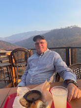
So how was my own experience? I had a long way to go to find out. I drove from my home in The Woodlands to
Hattiesburg, MS, where I met up with my friend David who was visiting there
himself from his home in Lake Oswego, Oregon.
We left bright and early the next morning to head up to Banner Elk NC, a
tiny place east of Boone, where my nephew Andy had graciously offered to put us
up and then drive us to and from the AT.
Since it was about 650 miles or so with the last hundred winding through
mountain roads I planned on spending a day after we arrived to rest and prepare
for the hike. However, with the help of
David and a book tape we arrived in good time feeling ready to go.
It is a testament to modern GIS
systems that we were able to find Andy’s home.
You do not ‘pass by’ where Andy and Lacy live. Andy and Lacy live way up on a hill back in the hills right
where the North Carolina, Tennessee, Virginia borders meet. It is a lovely place to bring up their two
young daughters, Maddie and Ceci. After
some debate, and looking at the weather which was predicted to be rainy on
Monday we decided to go a day early, leaving Friday and having Andy pick us up
in Damascus, Virginia on that rainy Monday instead of Tuesday. As David put it, ‘you do not want to have to
make camp with wet gear.’
Andy dutifully dropped us off at
Grayson Heights State Park, a goodly distance from his home. On the way there he swung through Damascus
and showed us a coffee shop where he could pick us up on Monday afternoon. Assuming we made it.


Andy and Lacy’s home in the
woods Tom and Dave at
the start of the adventure
We headed up the hills into Grayson Heights State Park
around 1030 on Friday, 4 April. Our
planned route on the first day would be only six and half miles up to the
Thomas Knob shelter, located near Mt. Rodgers, the highest point in
Virginia. Although relatively short, we
would have a climb of around 1400 feet.
What did not dawn on me was that we were starting at around 4,000 feet
which meant we would be spending the night up pretty high, fairly far north, very
early in April.
The hike started well - we were fresh and set a good
pace. The AT is generally well marked
using a white blazes of paint about six inches by two inches. The path is usually very obvious. Almost immediately we encountered our first
Nobo (north bound) thru-hiker, a young man wearing shorts and a determined
expression. He informed us that he had
been on the trail for 39 days. ‘About 14
miles a day; you get used to it.’
Wow. He had started hiking in
February during the worst winter in 40 years.
He was moving on and did not stay to chat.
We had not been walking thirty minutes before Dave asked me,
‘Did that should like thunder to you?’
It was. We soon began to feel
rain drops and so quickly put on our pack covers; so much for our plan of
avoiding the weather. We were both well
equipped with rain gear so we moved on between intermittent showers, so many so
that I had to remove my rain-streaked glasses.
The path was mostly over rocks, which grew slippery as we climbed
steadily past the painted white blazes. It grew colder and the wind began to gust
hard. Abruptly we came to a shelter hard
by the trail, much sooner than we had expected – around four hours into the
hike. I was glad for the cover. We found space in the shelter with a couple
who were north bound. Soon they were
dried out and headed on. David and I set
up on the wooden floor of the shelter and wandered about. The spring was down about a hundred yards
away from the direction the shelter opened to and with the wind now blowing
strongly, it was a cold walk. On the
other side the ground also fell away but with low evergreens which provided a
surprising amount of protection from the wind.
The terrain on that side was very different from the treeless
tundra-like windward side of the ridge.
Low evergreens shrouded moss-covered boulders in an altogether softer
atmosphere.
I was surprised to be comfortable in just my thermal
undershirt and fishing shirt. We were so
far ahead of schedule I was even able to take a short nap in my summer weight
mummy bag (rated for 32 degrees) before dinner.
I had heard the forecasted low that night would be about 32, so I
planned on bundling up inside the bag.
This was stupidity based in part on inexperience and part on, well,
sheer stupidity. First, I did not know
that synthetic fill sleeping bags like mine tend to lose effectiveness over
time. My bag, like most of my equipment,
was a legacy from my Eagle Scout son Travis and was over ten years old. Second, I did not consider that the forecast
was for a place a thousand feet lower than the shelter. Finally, I did not think about what might happen
if the winds which were now blowing hard increased to over 30 knots with gusts
even higher, and what would happen when freezing fog and sleet moved in. When those things happened an hour or so
before midnight combined with a wind shift that changed the shelter from merely
drafty to downright windy. It also went
from uncomfortably chilly to very cold.
David responded by moving up to the shelter’s loft where he passed a
reasonable night. I instead lay down
below and literally shivered through the night, trying various ineffective
palliative measures such as putting on another pair of socks and bringing my
towel into the sleeping bag. Of course I
did not think about the silver space blanket I keep in my daypack; just another
of my blunders that night. All in all I
think it was just about the most uncomfortable night I have spent since the one
in ICU.
I was delighted to see the first lightening of dawn, which
revealed the low evergreens opposite the opening covered in a proper Christmas
coating of white frost. Freezing wisps
of fog blew past the entrance. Once I
was up, dressed, and moving around I started warming up. Hot coffee and oatmeal finished the job and
we hit the trail. David and I knew that
this would be the longest leg of our trip: about 12 ½ miles to Lost Mountain
Shelter, and even though it was primarily downhill, the hardest leg as
well. We had no idea how hard it would
be. We made good time for the first
hour. Then when stopped after an hour
and took off our packs I noticed that I no longer had my sleeping bag and pad
that I had on top of my pack. Somehow
they had come off and I had not noticed.
There was nothing for it but to go back and find it. I shucked my pack while Dave stayed behind
and waited. I found the pad about ¾ of a
mile back down the trail – the sleeping bag about another ¼ farther on. I hurried back to David, well aware that my
boneheaded blunder cost us about an hour of time. It also put an extra two unnecessary miles on
my legs. I would pay for my carelessness
later in the day.
Despite the unnecessary delay we were able to track right
along, moving from alpine regions to deciduous-covered hills, and eventually
down to a golden meadow that lead up and over another hill, thence down to a
road at the foot of a very serious hill.
We took our lunch break there and headed up the hill, feeling
confident.
I was to find out that everyone tends to walk at a different
speed on the trail. David was slightly
faster than me on level terrain, a bit faster downhill, significantly faster
when it came to negotiating uneven footing and vastly faster going uphill. David goes uphill relentlessly, trying to
walk those upgrades into submission. My
style was more take a few steps, then take a few more.

 Tom at
Thomas Knob in the afternoon with gray sky Tom and Dave on the long winding
road
Tom at
Thomas Knob in the afternoon with gray sky Tom and Dave on the long winding
road
The day, and the hill, went on and on. David held back waiting on me until we made
it to the top of that long grade. There
was a spring just past there we used.
Springs were fairly common there; usually a horizontal pipe or gutter
came out of the ground where the water was welling up so it was easier to fill
your bottles. Although we were assured
the water was safe to drink, we still put the purification pills in – well
usually. One thing for certain: the
fresh mountain spring water was perfectly delicious.
It was around 1430 and David estimated we were just past the
halfway point. Because I was not
carrying a tent I needed a spot in the shelter.
David said he would walk ahead to reserve me a place. We figured that the last six miles had to be
downhill so we could probably make the next shelter in two and a half or three
hours. We were wrong. Although we lost a total of nine hundred feet
over the twelve and a half miles there were two places where there were serious
hills. He had just climbed one; another
waited a few miles down the track.
I felt pretty good the first couple of hours walking down
that hill. The ground changed
substantially as I walked down. I
crossed a gravel road and entered a green pasture. That lead to a stunning lane, overhung with
rhododendron; it looked like something from Better Homes and Gardens. The trail led through a number of low,
heavily overgrown hills, eventually crossing a paved road. This was unexpected. On the other side of the road the trail led
through more undergrowth and then up a hill – a sneaky big one. By this time the sun was trending down. By my calculations I should have been there
by now. Had a somehow walked past the
shelter? There was no help for it but to
keep on trudging up that long hill. At
times I thought I heard voices – oh boy, the shelter! But each time I just being optimistic; the
trail just went on and up. I was running
out of energy. My pack began to weigh on
my shoulders. Later I would find that
this was because my pack belt needed to be tightened by more than an inch. Worse, I was almost out of water. My backup plan if I did not find the shelter
by dark was to find a level place near the trail and sleep outside. It was not as cold as the night before and
the wind was down. I had the stove so I
could make a meal. Then it dawned on me
– without water I could not cook a meal.
Adding to my miseries, after ten hours of walking I was beginning to get
chafed. I had Vaseline in my pack, but I
did not want to stop and dig it out. All
in all Tom was pretty darn cranky at that point. I finally saw the top of the ridgeline just
as the sun was touching it. Shortly
thereafter I smelled smoke, and – there it was, the Lost Mountain shelter.
There was room for six in the shelter and five thru-hikers
were already there. Dave had saved me a
place and pitched his tent. I ditched my
pack and hobbled down to the spring.
There was still ample light for me to tend to my physical problems,
change clothes, set up for the night, and prepare dinner. Although Dave had had an easier time than I,
that did not mean he had an easy time.
After dinner he went straight to bed.
I stayed up for a while chatting with these men who had walked over five
hundred miles over the past month or so and would be hiking like this for
another four or five more months.
The life of a thru-hiker is by necessity austere. It is almost like taking several months’
worth of monastic vows of simplicity, poverty, and walking. Most of them are either in their early
twenties (pre-work) or their sixties (post-work). They tend to be very nice people who are lean
and fit.
To my astonishment my long hard walk (14.5 miles in 10 ½
hours) left me with virtually no aches and pains. I guess walking is inherently a low impact
activity. For whatever reason, neither
Dave nor I had any really joint pain or sore muscles during our hike.


Tom on the trail amidst trees on a rare flat place David against some rocks and
rhododendrons
The next day would be an easy one – only six and half miles
to the Saunders Shelter. We took our
time getting underway but still were on the trail an hour after light. Other than breakfast there is not much else
to do on the trail but get ready. We
must have been getting more accustomed to hiking as things were much easier on
the third day. David moved ahead with promises
to leave marks to direct me to the Saunders Shelter.
We noticed a several things while walking, aside from a few
walking staffs almost everyone had what they called tracking sticks; what I
thought were ski poles. Something like
that is absolutely essential. We would
each have fallen several times a day without the support they provided. Further, they reduce the stress put on your
lower body. I found it interesting that
not only were there a number of young women walking alone in the wilderness, no
one even remarked upon it. That, in and
of itself, is a testament to how safe people feel on the trail. We did notice several dogs accompanying their
masters on the long walk. Most had dog
packs that carried dog food, and in one case, a small rug for sleeping. We saw a fair number of people on the trail, perhaps
a hundred, mostly heading the opposite direction which is only to be expected. There was one only minority, a young Asian
woman. Discussion with experienced
hikers confirmed that wilderness hiking is definitely a Caucasian pursuit. No one seemed to know why.
I was fortunate that as I approached the Saunders shelter around
1430 to encounter several NOBO hikers who assured me the shelter was just
ahead. For the only time on our hike I
became a bit confused about the trail. I
saw some blue blazes which indicate a path to water. I not only needed to get more water, I also
knew the shelter would be close by the water.
Somehow I managed to get to the shelter from the wrong direction,
surprising David who was watching out for me.
Like the other shelters, Saunders was a three sided timber
structure located near a spring. There
was a simple privy the other direction.
No water there, and bring your own TP, but clean enough. Two segment hikers joined us later in the
day. They would be out for ‘just’ a
month before returning to work. The next
day, Monday, was still supposed to be rainy so we all made preparations for the
wet predicted on the morrow. It was
humbling to hear that these two men expected to hike the two segments that took
us two days, one of them a hard day, in one day. Youth and experience are a strong
combination. We were a bit concerned
that the shelter log book said that the shelter had lots of mice, a common
problem. You do not hang your food from
trees to protect them from bears; you dangle them from cords with lids blocking
the pesky little rodents from getting to your snacks. In the event, the mice were not a problem –
okay, a couple ran over David’s face as he slept, but that is okay; he is a
tough veteran Navy Seal.
We did get the expected rain about 0200, which felt cozy in
the shelter, and as predicted it was still raining lightly as dawn broke. We had nine and half miles to go to reach our
pickup point in Damascus and were on the AT by 0830. The rain slackened and then ended within an
hour. The only problem was that the
steep downhill trail was slick. It is no
joke to slide off the trail when it is cut back and forth into a very steep slope going down several hundred
feet. Your best hope would be that a
sturdy tree truck would stop your slide, although probably at the expense of
some broken bones. Much of the AT is out
of cell phone range; our segments certainly were. If you are hurt you have to find a way to
hike out to the nearest road. Sprains,
breaks, snake bites, and illnesses happen, but the death toll is somehow very
low.
Despite the conditions we made good time getting down the
long slope of the hill. We were moving
well, right next to a beautiful mountain stream when I noticed the Virginia
Creeper trail on the far side of the little river. That is a bike/hiking trail that runs through
Damascus.
‘Hey, Dave,’ I pointed, ‘that goes where we are going, and
it is nice and wide and even, and does not go over that hill up ahead. Too, bad it is on the other side of the
river.’
‘I saw a footbridge.
Let’s get on that trail.’ There
are advantages and disadvantages to hiking with a Seal. Yes, David is very fit, and treats hiking up
a mountain as a personal challenge, leaving lesser mortals (that would be me)
far behind. On the other hand he is
resourceful. And he cheats whenever he
can.


David on the bridge on the last day A scenic creek; usually we
were too involved to take photos
Five minutes later we were on a nice flat stretch of trail
making excellent time. It was so nice I
was even able to keep up with David.
Although the Creeper Trail was a bit longer than the AT route, it was so
nice we walked about three times faster.
Soon we were paralleling a black top road that led into Damascus.
When we saw we were actually entering the outskirts of town
I called Andy to let him know. He was
astonished that we had covered the nine and a half miles in just over four
hours. So were we. That did not stop us from heading to a lovely
local coffee shop where we had coffee and then breakfast – a big one.
I have to admit that hiking the AT was much more demanding
than I expected. However, I admit that
most of my problems were due to my general inexperience and specific
dumbshittedness. We did not take many
photos in part because the going was too tough, I had to manage my cell phone
battery, and frankly the terrain was not all that scenic. It was a bit too early in the year for
flowers or even much early growth. We
were fortunate that Andy provided us with hospitality,
transportation, guidance,
and some necessary loaned items – a lightweight stove and some warm wool
socks. We are indebted to both him and
his lovely wife Lacy.
Besides, it was supposed
to be difficult, challenging, and a bit dangerous. It was not a vacation, it was an adventure.
No comments:
Post a Comment